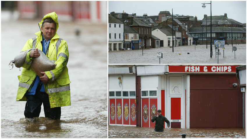
Aberdeenshire, Ayrshire and Dumfries and Galloway bore the brunt of the severe weather which caused disruption to road, rail and ferry services right across the country.
The Scottish Government’s resilience committee has met to assess the response to what environment minister Aileen McLeod described as a “very serious situation”.
About 6,000 homes in the north were without power on Wednesday afternoon as the persistent rain and gales hampered efforts to restore the supply.
SSE said faults were caused by wind damage and trees or other debris on the lines.
Travel on motorways and rural routes alike have been severely disrupted by surface water and motorists were urged to avoid unnecessary journeys.
More than 100 flood warnings were in force, although a Met Office amber weather warning was due to expire at 3pm on Wednesday.
The Scottish Environment Protection Agency (Sepa) has issued a “severe flooding – danger to life” warning for Whitesands in Dumfries and Galloway.
*CLOSED* ⚠ #M74 J13 Abington *CLOSED IN BOTH DIRECTIONS* due to severe flooding. Div in place #BeAware pic.twitter.com/vis916vTEc
— Traffic Scotland (@trafficscotland) December 30, 2015
Ms McLeod said: “We are dealing with a very serious situation as a result of Storm Frank.
“Weather warnings from the Met Office have unfolded as forecast and much of Scotland has been experiencing strong winds, torrential rain and rising rivers.
“The Scottish Government’s resilience team is closely monitoring the situation which is still developing as persistent rain continues to fall onto saturated ground – and is expected to deteriorate further as river levels continue to rise, even after the rain has stopped.
“It is imperative that people look for and take heed of the latest warnings, information and advice from Sepa, Police Scotland and Traffic Scotland.
“In particular, consider whether you need to travel and take all possible precautions to stay safe, particularly in the worst-affected areas.”
Impact that #stormfrank been having on line near #saltcoats pic.twitter.com/XGCjllDJX3
— ScotRail (@ScotRail) December 30, 2015
#StormFrank is causing issues. Balloch's rail line is currently under water. See https://t.co/zPWyOwHPbg for updates pic.twitter.com/auRJlww0FN
— ScotRail (@ScotRail) December 30, 2015
In Ballater, Aberdeenshire, residents from Anderson Road, Deebank Road and Albert Road have been evacuated and a rest centre set up at the Victoria Barracks and nearby Aboyne Academy.
Vincent Fitzsimons, from Sepa, said: “The worst of the rainfall has largely passed but larger rivers will take some time to react as the water moves down towards the sea.
“Some are reacting now but in areas like Dumfries the worst of the flooding is expected to coincide with high tide mid-afternoon today.
“Rivers further east will take longer to respond. Areas like Callander, Perth, Deeside and Spey will continue to see rising levels throughout the day and some will not peak until the 31st.
“However, from Friday the situation should start to improve for everyone.”
Ballater pic.twitter.com/qdmMsW25Nk
— Nick the Nanny (@nannynick) December 30, 2015
A93 Ballater high street #Flood #StormFrank pic.twitter.com/gzZHj9ZfoH
— Nick the Nanny (@nannynick) December 30, 2015
Forecasters at Meteogroup said Braemar in Aberdeenshire has been the wettest place in the Scotland since midnight after receiving 64mm of rain up to 2pm on Wednesday.
Tyndrum in the Stirling Council area received 58mm and 39mm fell in Eskdalemuir in Dumfries and Galloway.
Glasgow was the wettest city with 43mm rainfall compared to 9mm in Edinburgh.
READ MORE:
Floods minister warns of ‘very bad situation’ as fresh storm approaches

Enjoy the convenience of having The Sunday Post delivered as a digital ePaper straight to your smartphone, tablet or computer.
Subscribe for only £5.49 a month and enjoy all the benefits of the printed paper as a digital replica.
Subscribe