I could have driven the length of the Angus coast in less than 40 minutes. Instead, I chose to fully immerse myself in a journey by bike, kayak and on foot.
The aim of the one-day adventure was to experience the landscape and coast up close in a region I have rarely visited. Too frequently, it seems, we are in a hurry to travel when we could slow down and better enjoy the sights, sounds and points of interest.
For the A-to-B multi-sport trip, I enlisted the help of a friend to deliver items of kit to me each time I changed mode of transport, as well as booking a paddling outing with Arbroath Cliff Tours.
The start point was Montrose, just after 9.30am, where I eyed the haar rolling in from the sea and wondered nervously if it would bring rain or, more hopefully, disappear to reveal sunshine.
The town, once a thriving fishing port, is home to an unusual landmark located close to the harbour, on the northern shore of the River South Esk.
The Bamse memorial honours a heroic St Bernard owned by Captain Erling Hafto from the Norwegian Navy during the Second World War. Bamse went to sea on the minesweeper Thorodd, stationed for a time in Montrose, and achieved legendary status as a mascot.
The statue faces towards Norway and it was a fitting start to my coastal adventure, given that I was going to be looking out to the North Sea for most of the day.
I rode out of Montrose on the National Cycle Network Route One then detoured on a rough path to reach Scurdie Ness. The headland on the opposite bank of the river estuary is home to a lighthouse built in 1870 by David and Thomas Stevenson – sons of civil engineer Robert Stevenson.
Back on Route One, quiet roads took me further south, skirting around rolling fields, through farmland and past scattered houses. While chilly in the coastal haar, the mist added atmosphere to the views.
I enjoyed a few easy gradient climbs to warm up and then some lovely descents. After one longer climb, a delightful free-wheeling downhill took me to Lunan Bay.
This wide beach is backed by sand dunes and framed by low cliffs to the north and south. I left my bike on a viewing deck for a stroll by the sea.
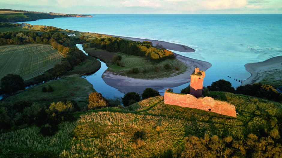
The ruins of Red Castle sit on a hill overlooking the bay. It dates from the 12th Century and was built for King William the Lion of Scotland to defend against Viking invaders.
Only a tower added in the 15th Century now remains but the fortification was a striking sight as I cycled past.
Route One took me away from the coast for a while and between undulating swathes of farmland. The longest ascent of the 17-mile cycling section came next, although I never needed my easiest gear.
I stopped to look across fields, allowing my eyes to focus along lines between young crops and out to sea. Strips of sunlight spread out from below the clouds and lit the distant horizon. The layers of cloud, sky and light were beautiful against green fields.
Turning off Route One to the east, the road descended to the coastal village of Auchmithie.
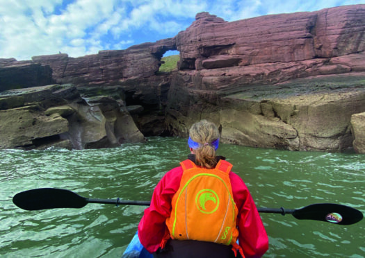
My friend arrived and, as I swapped from cycling to kayaking kit, Arbroath Cliff Tours founder Cameron Smith met me. Our craft was a two-person sit-on kayak, which allowed us to paddle along a coast of spectacular cliffs and rock architecture.
Cameron, an Angus local, pointed out numerous geological highlights and guided us into stunning caves – including Brandy Cave, which was once used by smugglers, and Gaylet Pot with a long tunnel leading to a beach.
Another cave extends to more than 300ft long with amazing stalactites.
We also spotted the Deil’s Heid, a sea stack so-called because it looks like a devil’s head, and Needle’s Eye, which takes the form of a giant hole in the rocks.
The noise of screeching seabirds, resident on the high cliffs, was deafening at times. The three-mile sea journey to Arbroath was over too quickly – and it was time to switch my mode of transport.
I changed from wetsuit to running kit to start the 14-mile run from Arbroath to Monifieth. I jogged west into the centre of Arbroath. The sun had burned off the clouds and I suddenly felt hot and tired.
Passing the old harbour, I spotted a bench to sit on and enjoy more sea views. I refuelled with snacks and water, and felt almost immediately revived.
NCN Route One took me to West Links beach, just west of Arbroath, which is a lovely stretch of sand. I enjoyed the sight of the gentle waves as I headed between the beach and the town’s golf course.
East Haven beach came next with a gorgeous arc of sand backed by low dunes. A chainsaw carving there remembers the role of fishing in the development of the community – East Haven is one of the earliest recorded fishing communities in Scotland, dating back to 1214.
Continuing along the coast, although a little further inland, I ran on to reach West Haven and then into the eastern end of the golf town of Carnoustie.
There is another superb beach in the middle of the town that stretches south to wrap around Buddon Ness.
The headland of heath and dunes is home to Barry Links, largely occupied by a military training area and Barry Buddon camp, and so it is inaccessible to the public. Instead, I ran along a path on the outside of a high perimeter fence.
It was late afternoon by this point and my weary body was keen to catch a glimpse of Monifieth. Another popular golf destination, the town grew in the 18th and 19th Centuries based on the whale and sea industry, then prospered with the jute boom of Victorian times.
The boundary between Monifieth and Broughty Ferry is also the edge of Angus and the city of Dundee, where my self-created finish line was located. The total distance was 35 miles – but at no point had I felt hurried as I cycled, kayaked and ran along the coastline.
It had been a rewarding journey because I’d travelled at a speed that allowed me to feel immersed in my surroundings.

Enjoy the convenience of having The Sunday Post delivered as a digital ePaper straight to your smartphone, tablet or computer.
Subscribe for only £5.49 a month and enjoy all the benefits of the printed paper as a digital replica.
Subscribe
