Snow and ice are forecast to hit Scotland within days on the back of the storms that continued to batter the country yesterday.
The prolonged stormy spell is expected to freeze over from Tuesday with a 500-mile-wide jet of cold air from Greenland.
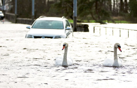
It follows what is already one of the wettest Februarys on record with widespread flooding across large parts of the country last week.
Heavy rain on Friday led to vehicles being stranded in Paisley and Lochwinnoch in Renfrewshire and in Old Kilpatrick, West Dunbartonshire.
Road, rail and ferries were hit by the conditions and four SPFL football matches fell victim yesterday including the Championship game between Partick Thistle and Dunfermline Athletic.
Yellow warnings of snow and ice were in place until 10am today and the Scottish Environment Protection Agency yesterday issued 42 flood warnings and 12 flood alerts.
The RAC said it was braced for in excess of 10,000 call-outs today and tomorrow as treacherous road conditions persist.
Spokesman Simon Williams said: “Monday’s forecast is worse timing than storms Ciara and Dennis as the roads will be much busier.”
The Met Office said winter’s worst cold spell follows on Tuesday and Wednesday, with daytime highs up to just 4C for much of the country, with the windchill factor making temperatures feel like zero degrees.
Forecasters added snow showers could fall “anywhere” in coming days. The Met Office said an inch of snow was due on higher ground, with freezing nights bringing ice risks in many areas.
The misery is to continue with more downpours and gales due from Thursday into the weekend. Met Office figures show 152mm of rain – more than double the average – has fallen already this month in Scotland.
The month is already in the top 10 wettest since records began in 1931. Another 50mm rain would put it in the top three.
A warning for snow begins at 6am tomorrow with a 15-hour warning beginning later in the morning for winds gusting to 70mph.
Met Office spokesman Grahame Madge said: “It looks like this very unsettled period will continue until month’s end. Indeed, onward forecasts into March suggest spells of wet and very windy weather are likely.”
Today
Cold, with sunny spells and wintry showers. Max 8C (46F). Min -3C (26F).
Tomorrow
Snow, turning to rain later. Very windy. Max 8C (46F). Min -2C (28F).
Tuesday
Wintry showers on the hills. Remaining windy. Max 6C (42F). Min -3C (26F).

Enjoy the convenience of having The Sunday Post delivered as a digital ePaper straight to your smartphone, tablet or computer.
Subscribe for only £5.49 a month and enjoy all the benefits of the printed paper as a digital replica.
Subscribe