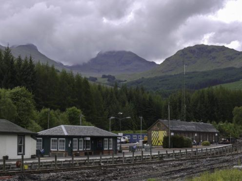
Its distinctive, rugged outline ensures rocky Cruach Ardrain is a hill familiar in outline, far and wide. There’s a wee hill I climb often, for training, just north of my home in the Trossachs.
The view from the summit is a wonderful panorama, a great ring of peaks from Ben Lomond in the west, then Ben Venue, on to Beinn Tulaichean, Cruach Ardrain, Stob Binnein, Ben More, all the way round to Ben Vane and Ben Ledi in the east. For me, it’s craggy Cruach Ardrain that steals the show.
It’s far smaller than its immediate neighbours – towering Ben More and Stob Binnein, both aesthetically pleasing hills – but Cruach Ardrain’s steep, broken north-eastern aspect gives it real drama.
It lies at the heart of the seven Munros just south of Crianlarich – and of the five western Munros in that group, it’s easily the finest summit. The hill is often climbed along with the smaller Munro, Beinn Tulaichean, which lies about 2km (1.2 miles) away at the southern tip of Cruach Ardrain’s south ridge.
They don’t really feel like separate hills. A common way of climbing them is from Inverlochlarig, at the end of a long section of single-track road from Balquhidder off the A84.
It’s a bit of a slog up steep grass and not the best way up the hills. I reckon the approach from the Crianlarich side is much nicer – it gives you the chance to better appreciate the rough character of the hill.
And you can always add on Beinn Tulaichean as a there-and-back if you have time. Ascent from the Crianlarich side is a particularly fine winter outing for experienced mountaineers.
In fact there are even some graded routes for climbers, probably the best-known being Y Gully, a winter Grade 1. You can turn the route into a bit of a horseshoe by carrying on from the summit to the Munro top Stob Garbh – the initial part of this is very rocky and steep and requires great care, particularly when it’s icy.
Pronunciation: Croo-ach Ar-dren
Meaning: Stack of the high peaks
Height: 1,046m (3,432ft);
Rank: 87
OS Landranger Maps 50, 51 & 56
Summit grid ref: NN409212 (cairn)
Nearest town: Crianlarich is around 5km (3miles) north-west. Although a small village, it has a railway station, several hotels, pubs and a youth hostel. It also has a small corner shop, with a limited range of outdoor kit.
Start grid ref: NN368238
Distance: 10km (6.2 miles)
Ascent: 1,000m (3,281ft)
Time: 5hrs
Start at lay-by off the A82, south of Crianlarich. Follow track along River Falloch for about 1km.
North-west for 1km to ridge leading over Grey Height and Meall Dhamh. Lose height before stiff climb up Cruach Ardrain. While confusing in mist, the summit cairn is unmistakable, a tremendous viewpoint.
The route stats above assume you’ll retrace your steps – but there are other options. Beinn Tulaichean lies 1.5km along Cruach Ardrain’s south ridge and involves a drop-off of 120m. Another option is to continue to Stob Garbh.
The descent requires care, and the route to the top is over an ill-defined ridge.
Once over Stob Garbh, continue along the ridge for about 0.5km before heading north-west into Coire Ardrain. Then traverse below Grey Height to the bottom.
Mountaineers the world over are familiar with Naismith’s Rule – the formula used to give a rough timing for how long a route should take.
It was devised by Scottish mountaineer William W Naismith in 1892, while he was traversing Cruach Ardrain on his way to Ben More. It’s been tweaked slightly over the years – and assumes a fairly decent level of fitness – but it’s pretty accurate and a useful planning tool. The rule of thumb is to allow one hour for every 5km (3.1 miles) going forward, and an additional hour for every 600m (2,000ft) of ascent.
Naismith was a founder member of the Scottish Mountaineering Club and a noted climber with many first ascents. In 1894, he was the first to climb Ben Nevis’s Tower Ridge – and thus, as tradition dictates, was given the honour of naming the route.

Enjoy the convenience of having The Sunday Post delivered as a digital ePaper straight to your smartphone, tablet or computer.
Subscribe for only £5.49 a month and enjoy all the benefits of the printed paper as a digital replica.
Subscribe