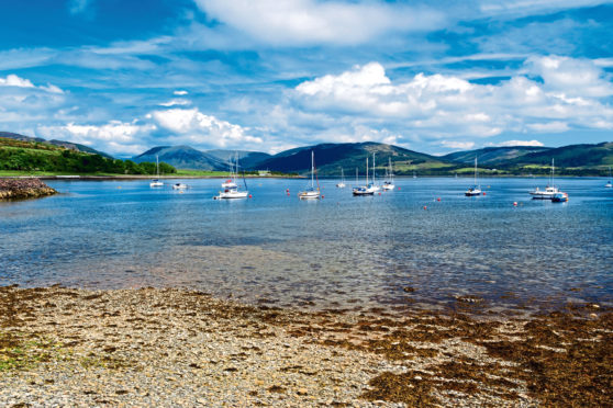
As I sit on the bank of Loch Fad, stunningly located on the Highland Fault Line on the Isle of Bute, I’m transported back to a school geography lesson.
I can recall the teacher telling me about the geological wonder, a fault line that cuts Scotland in half, with dramatic Highland scenery to the north and the rolling Lowlands to the south.
On Bute, this fault line similarly divides the landscape from Scalpsie Bay in the south-west to the main town of Rothesay. While the island measures just 15 miles by four miles, it boasts a varied scenery.
There is another significant geological feature in southern Bute, where basalt lava outflows, created from volcanoes that were active 250 million years ago, have formed into mini ridges, hills and cliffs.
The later Ice Age also left its mark on this island with several U-shaped valleys and raised coastal beaches. Over three days of walking and wild camping on the small isle, I devour the landscapes.
My focus for the island adventure is the 30-mile West Island Way (WIW), through southern and northern Bute. Opened in 2000 as Scotland’s first official long-distance island footpath, it starts at the picturesque Kilchattan Bay.
A signpost points along a path that hugs the south-eastern edge of Bute, skirting a rocky shoreline with spectacular views across the Firth of Clyde and towards the isles of Great and Little Cumbrae.
A large rock slab, known as Hawk’s Neb – meaning Hawk’s Nose or Beak – reveals layers of old red sandstone while, further on, another sign points the way to a low hill with fine views and the ruin of Kelspoke Castle.
At a headland further south, a squat lighthouse, Rubh’an Eun, guards the west side of the entrance to the Clyde estuary.
Back on the WIW another coastal gem, Glencallum Bay, forms a crescent of dark-grey sand at the foot of Glen Callum and its strange landscape of volcanic rocks.The Way turns inland just past Glencallum Bay to climb several small ridges of volcanic rock. Pretty Loch na Leighe, viewed from the path just above, is a haven for wildlife, such as whooper swans, little grebes, teal and herons. Bute is also home to osprey, conies (rabbits), hare, deer, foxes and wild goats.
Further on, the views widen again with the fertile land of the south-west coast gently falling towards the sea and, in the distance, the outline of the Isle of Arran.
The atmospheric site of St Blane’s Chapel rests in a verdant hollow, set beside tall trees. Formerly the capital of Bute, the ruined chapel dates to the 12th Century and is associated with St Blane, a monk born on Bute who founded Dunblane Cathedral.
The next section is the steepest on the southern loop but the reward is a panoramic view over Kilchattan Bay.
The five-mile circular stage of the WIW is the ideal distance for a half-day hike. As the light starts to fade, I find a quiet spot for a wild camp. Awakening to a chilly, bright morning, I pack up to head for Port Bannatyne, some 11 miles away.
I follow a wide track known as Lord James’ Ride, so-called because a young descendent of the Marquess of Bute wanted a place he could ride his horse fast and straight. A sign offers a short detour to Mount Stuart, the eccentric neo-Gothic mansion house built by the Third Marquess of Bute in Victorian times.
I continue past Loch Ascog, a popular fishing spot. From here, the WIW journeys into Highlands-style landscape. It’s possible to drop in on Rothesay for supplies before reaching Port Bannatyne.
My second wild camp is also on the coast, this time the eastern shoreline near Kames Bay.
The final section follows a more remote and rugged 13.5-mile loop. From Kames Bay a short section of road reaches the Tramway Walk, a horse-drawn tramway built in the late-1800s to take holidaymakers across Bute to Ettrick Bay.
Joining a track north, the WIW ascends through farmland and moorland in Glen More to enter forestry. At the north end of the route there are several options: walk the A886 south along coastline, and follow signposts over hills and moors or the three-mile Balnakeilly Loop before taking either route south.
I recommend the Balnakeilly Loop that heads to Rubha a’ Bhodaich, passing a Second World War bunker and decoy village site, and the ruins of an old farmstead. Nearing the end of my journey, a challenging but wonderfully wild route takes me over several hills.
As I make the last descent on tarmac towards Kames, the splendid castellated mansion house of Kames Castle comes into view.
As well as boasting an impressive variety of geology for one small island, Bute is home to a rich history, one that will continue to draw me back.
We hope you’re inspired to get outdoors but remember, travel for now is prohibited unless for essential reasons. See gov.scot for the latest info

Enjoy the convenience of having The Sunday Post delivered as a digital ePaper straight to your smartphone, tablet or computer.
Subscribe for only £5.49 a month and enjoy all the benefits of the printed paper as a digital replica.
Subscribe