Two summits into a 40km (25-mile), six-mountain challenge in the Cairngorms and I began to relax. It had taken less than two hours to run – and fast walk – from Cairngorm Mountain car park to the top of Cairn Gorm at 1,244m (4,081ft) and then Ben Macdui at 1,309m (4,295ft).
These are two of the tallest mountains in the UK – in fact, Ben Macdui is second in height only to the UK’s tallest Ben Nevis – but we started at an elevation of more than 640m (2,100ft) and the trails were easy to follow.
Along with my husband Gordon and two friends, The Scots Magazine editor, Robert, and Stewart, our group made easy progress. Thanks to fine weather, navigation was straightforward and we carried only essential kit.
The views were sublime. From Cairngorm summit, we looked over Rothiemurchus Forest and the dramatic northern Corries.
En route to Macdui, we gazed down in wonder at the glacially eroded cirque of Coire an t-Sneachda and from Macdui’s peak we had sweeping views of the Cairngorms National Park.
But then I saw it. As we descended the steep and rocky south-west flanks of Macdui towards the famous hill pass of the Lairig Ghru, I looked ahead and up.
Towering above on the other side of the grassy glen, a long ridge of high summits spanned the horizon, including our next four summits – The Devil’s Point at 1,004m (3,294ft), Cairn Toul at 1,291m (4,235ft), Sgor an Lochain Uaine at 1,258m (4,127ft) and Braeriach at 1,296m (4,252ft).
Cairngorm and Macdui together, or this ridge of four summits, would provide a challenging day. In fact, my original plan had been the four until my pals persuaded me to add on “just another two summits”.
Looking at an OS map, there was an obvious route to form a circuit to link all six mountains although the distance and total ascent seemed challenging.
Five of the six summits were 4,000-footers, out of only nine UK mountains of more than 4,000ft (1,219m).
“We dare you,” they all told me, individually, and, after considered thought about my fitness, I did dare.
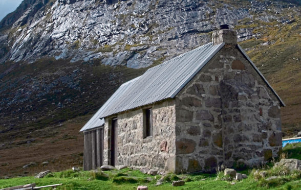
At Corrour Bothy, around halfway along the Lairig Ghru, we took a rest for food and to refill water bottles. Pitched all around, one and two-person tents revealed the popularity of this remote spot.
Although the smallest of our day’s summits, The Devil’s Point required a constant push up a path into a corrie. We took our time, chatting away, one behind the other.
Shielded from the wind, we soon became warm and stopped to rearrange layers of clothing. A zig-zagging path ascended the mountain’s headwall to a wide bealach – mountain pass – and another 90m (300ft) ascent on an easier gradient took us to a cairn on The Devil’s Point.
The views south along Glen Dee, with the river snaking into the distance and the many peaks of the southern Cairngorms, were beautiful.
Retracing our steps to the bealach, this time at a run, we could see the extensive edge of the ridge with its many pointy peaks.
A longer climb on wide slopes heading northwest took us to the summit of Stob Coire an t-Saighdeir at the edge of a precipitous corrie. We ran further along the ridge before a short descent, then slowed to a fast walk up a field of boulders to Cairn Toul summit with wonderful views towards Braeriach and a pretty lochan.
Sgor an Lochain Uaine – better known as Angel’s Peak – was the next goal. It only gained its classification as a Munro in 1997. There are 282 Munros in Scotland – mountains of more than 914m (3,000ft) – and Angel’s Peak is the fifth highest. We picked our way again over the boulder-strewn plateau, by now on tiring legs, to descend to another bealach and then up to the summit.
Following the rim of the plateau, we ascended to another high point, Carn na Criche, above the rocky buttresses of Garbh Choire Mor.
By now, I couldn’t decide if I was happy to see the terrain flattening ahead, and I could see the final peak of Braeriach was a long way in the distance.
We stopped near the Wells Of Dee, which is the highest source of a UK river. Rejuvenated, we pushed on to Britain’s third highest mountain, Braeriach. Another great corrie, Coire Bhrochain, plunged from the top and looking back along the glen we could see how far we had come.
Once we reached the final summit, there was still around 11km (seven miles) to go – and more ascending.
Once I spotted the track winding its way back towards the ski road, I found the energy to set off at a fast jog, revelling in a lush landscape of purple heather and grass moorlands and a path edged with pretty wildflowers.
The further I descended, the higher my spirits soared until I saw the road back to the car park.
Big challenges usually reap great rewards and the run to the five 4,000-footers, plus The Devil’s Point, more than ticked both boxes.
Kit List
- Running clothes and trail running shoes
- Small running pack
- Lightweight waterproof jacket
- Lightweight waterproof trousers
- Lightweight insulated jacket
- Gloves
- Buff
- Foil emergency blanket
- Small medical kit – pain killers and blister plasters
- Food and water
- Map, compass, and route downloaded onto the OS Map phone app
- Mobile phone

Enjoy the convenience of having The Sunday Post delivered as a digital ePaper straight to your smartphone, tablet or computer.
Subscribe for only £5.49 a month and enjoy all the benefits of the printed paper as a digital replica.
Subscribe