A large-scale geophysical survey of a National Trust estate as part of its plans to restore nature has uncovered evidence of two previously-unknown Roman villas.
The charity commissioned the survey across more than 1,000 hectares (2,471 acres) at the Attingham Park estate in Shropshire, to map the area’s archaeological remains.
The findings will help the National Trust work with its tenant farmers on the estate to create habitat such as woodlands and wetlands to help nature recover in the area, while protecting important archaeological remains.
The estate encompasses part of the buried Roman city of Wroxeter (Viriconium Cornoviorum), which is cared for by English Heritage.

Teams from Magnitude Surveys used the latest technology to carry out a magnetometer survey, which can survey large areas in a relatively short time and records subtle changes in the local magnetic field, highlighting buried features which have different magnetic properties from the surrounding soil.
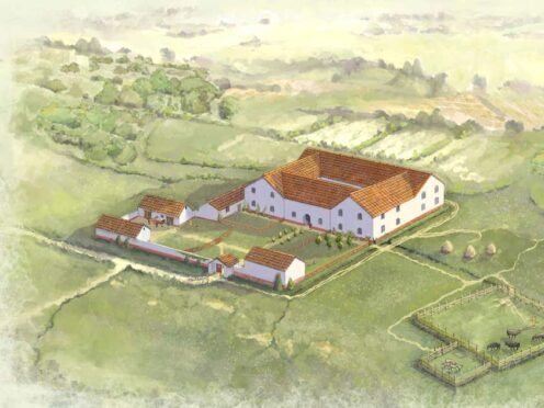
The survey – the largest the National Trust has ever commissioned – revealed evidence of what are believed to be two previously unknown large Roman rural villas and a Roman cemetery on a road leading out of Wroxeter.
The villas show evidence of at least two construction or occupation phases, with floor plans that highlight internal room divisions and outbuildings.
The National Trust said it is likely the villas would have had features typical of such country estates of this type, such as underfloor heating known as hypocausts, their own bath houses, and mosaic floors.

Only six such other villas are known in Shropshire.
The survey also detected eight ditched enclosures and remains, possibly Iron Age or Romano-British farmsteads, four of which were unknown until now.
The trust said they are likely to have been small farms, perhaps supplying food for the nearby city.
The survey also uncovered evidence of several Roman roads to the west of Wroxeter and has added to archaeologists’ understanding about the settlement activity immediately outside the city’s defences, and the changing uses of the area during the Roman period.
Elsewhere on the estate, new features linked to a previously-known Anglo-Saxon great hall have been detected.
The survey also detected substantial geophysical evidence to further the existing knowledge of RAF Atcham, an airfield used in the Second World War, and its runways, perimeter defences and landscaping.
National Trust archaeologist Janine Young said: “Attingham Estate has always been known to have high historical and archaeological significance which has now been confirmed by the largest geophysical survey the National Trust has ever undertaken.
“We’ve seen tantalising hints of these remains over the years, with evidence showing up in cropmarks, aerial imagery and through small surveys and excavations.
“But, until now, what lies beneath the surface of the ground has never fully been investigated.
“This new geophysical survey has really transformed our knowledge by establishing a comprehensive ‘map’ of what is below our feet, providing us with a fascinating picture of the estate’s hidden past, revealing previously unknown sites of importance.”
The National Trust said the results will help it to plan land use changes with its tenants to restore nature, capture carbon and build resilience to the impacts of climate change such as flooding in the area.
It will help it make decisions such as where to plant trees, restore natural pastures, create nature-friendly arable land or wetlands, and how to manage flood plains, the charity said.

National Trust project manager Alice Collier said: “Having this detailed knowledge of the way the land has been used in the past is directly informing our plans for how the land could best be used in the future for the benefit of nature and people.
“The survey results are helping to influence the location and design of potential woodland and wetland projects by highlighting areas we will need to work around to protect important archaeological remains.
“We are working collaboratively with our farm tenants, to look at how we can deliver changes for nature and help to mitigate and adapt to the effects of climate change whilst respecting the heritage of the landscape.”
English Heritage said the survey results are “exciting” and will help increase knowledge about Wroxeter.
Senior properties curator Winn Scutt said: “Although we know a great deal about the city of Wroxeter in Roman times from surveys carried out in the 1990s, the wider area around the site still has much to reveal.
“This latest geophysical survey by the National Trust is exciting, and, along with further excavation by English Heritage this July and surveys by Historic England, we are all vastly growing our understanding of this important historic site.”

Enjoy the convenience of having The Sunday Post delivered as a digital ePaper straight to your smartphone, tablet or computer.
Subscribe for only £5.49 a month and enjoy all the benefits of the printed paper as a digital replica.
Subscribe